A temporary improvement in the weather with rising temperatures over the weekend is expected, followed by a new significant change from the beginning of next week, bringing widespread and locally heavy rainfall, according to meteorologist Thodoris Kolydas.
In a post, the former director of the Hellenic National Meteorological Service (HNMS) noted that today only limited weather phenomena will occur, mainly in the southern parts of Greece, and these will gradually weaken.
Over the weekend, weather conditions will improve noticeably, with higher temperatures in most areas and generally mild conditions.
However, from early next week, another change in the weather is expected, with increased rainfall mainly in western and northern regions as well as the eastern Aegean, which may be locally heavy.
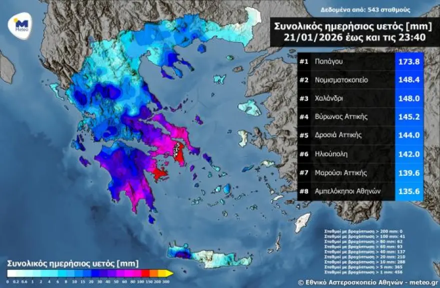
Final rainfall totals from the January 21, 2026 storm
The storm on Wednesday, January 21, 2026 caused significant rainfall across most of the country. Based on both forecast data and subsequent measurements from the network of automatic weather stations of the National Observatory of Athens / Meteo.gr, the Rainfall Episode Risk Index (RPI) (Category 5) was confirmed, as very high rainfall totals were recorded, mainly in Attica, eastern Peloponnese, and Evia.
The highest rainfall totals recorded up to Wednesday evening were in the Papagou area of Attica (173.8 mm), at Nomismatokopio (148.4 mm), in Chalandri (148 mm), and in Vyronas, Attica (145.2 mm).
The map below shows the total rainfall amounts recorded up to 23:40 on Wednesday, January 21, 2026, as measured by 543 meteorological stations of the National Observatory of Athens / meteo.gr, with the eight highest totals highlighted.
Today’s weather
Rain and thunderstorms are expected in the eastern island regions, rain in Crete and western mainland areas, and from the afternoon onward thunderstorms in the southern Ionian Sea, southern Peloponnese, Crete, and the Cyclades. In the rest of the country, locally increased cloudiness is expected. Visibility will be limited over mainland areas during the morning and evening hours.
Temperatures will range from -3 to 7°C in western Macedonia, 1 to 12°C in the rest of Macedonia, 0 to 8°C in Thrace, 4 to 14°C in Epirus, 4 to 14°C in Thessaly, 6 to 16°C in Central Greece, 3 to 16°C in the Peloponnese, 8 to 14°C in the Ionian Islands, 8 to 12°C in the northern Aegean islands, 12 to 15–17°C in the remaining Aegean islands, and 13 to 18°C in Crete.
Winds in the west will blow from southerly directions at 3 to 5 Beaufort; in the east from westerly and gradually southwesterly directions at 3 to 4 Beaufort; and in the southern seas locally up to 6 Beaufort.
In Attica, increased cloudiness with local rain is expected until morning. Winds will blow from northwesterly and gradually southeasterly directions at 2 to 4 Beaufort. Temperatures will range from 6 to 14°C.
In Thessaloniki, increased cloudiness is expected. Winds will be northwesterly at 2 to 3 Beaufort. Temperatures will range from 1 to 11°C.
Weather on Saturday, January 24, 2026
In western regions and the eastern Aegean, increased cloudiness with local rain and occasional isolated thunderstorms. In the rest of the country, few clouds temporarily increasing with light local rain. Light snowfall will occur from the afternoon in the mountainous areas of Epirus and western Macedonia.
Winds will blow from southerly to southwesterly directions at 3 to 5 Beaufort, strengthening during the night.
Temperatures will show no significant change, reaching 14°C in the north, 15 to 17°C in the remaining mainland areas, and 18 to 19°C in island regions.
Weather on Sunday, January 25, 2026
In western and northern regions, increased cloudiness with rain and from midday sporadic thunderstorms, which in the west may be locally strong. In the rest of the country, few clouds temporarily increasing with light local rain, and in the eastern Aegean islands and the Dodecanese during the morning hours isolated thunderstorms. Light snowfall will occur in northern mountainous areas and, from the evening, also in central mainland mountainous regions, intensifying overnight.
Winds will blow from southerly directions: 6 to 7 Beaufort in the west and 7 to 8 Beaufort in the Ionian Sea; in the east 5 to 6 Beaufort, increasing from the afternoon to 6 to 7 and locally up to 8 Beaufort in the Aegean Sea.
Temperatures will rise.
Ask me anything
Explore related questions