Today, Monday February 16, rain and thunderstorms are expected, possibly locally intense, in the islands of the Eastern Aegean and the Dodecanese, and until the morning hours in the southern Ionian Sea and western and southern Peloponnese, according to the Hellenic National Meteorological Service. On Tuesday, a new, fast-moving but dynamic weather system is expected.
In a post, meteorologist Giannis Kallianos notes that “on Tuesday an express bout of bad weather is coming, but with locally high rain rates over already saturated soils.”
As he explains, it is a deep low-pressure system that will organize over the Adriatic region and move east–southeast, approaching and crossing the northern parts of the country within 24–36 hours. The pressure at the center of the low is estimated near 995 hPa, with possible further deepening to 992–991 hPa.
The system will be accompanied by cyclonic circulation, favoring strong upward motion and the development of vertically developed cloud masses.
Which areas will be affected
During Tuesday, rain and thunderstorms will occur in most parts of the country. The most persistent and potentially intense phenomena are expected in parts of the Ionian Islands, Epirus, Western Central Greece, western, central and southern Peloponnese, Kythera, western and southern Crete – mainly the southwest – Thrace, the northeastern and eastern Aegean up to the Dodecanese, and possibly parts of the southern Cyclades.
In specific areas, such as southwestern Peloponnese, the islands of the Eastern Aegean and southwestern Crete, phenomena may be particularly torrential, with local rainfall totals possibly exceeding 70–80 millimeters.
Winds and temperature
In the Ionian Sea, northwesterly winds of 6–8 Beaufort will blow; in the central and southern Aegean, westerly to southwesterly winds of 6–8 and locally 9 Beaufort; and in the northern Aegean, southerly to southwesterly winds of 5–7 Beaufort.
Temperatures will range in northern Greece from 8 to 14°C, in the west from 14 to 15°C, in the eastern mainland from 16 to 18°C, and in the island regions from 15 to 19°C. Temporary snowfall will occur in the mountainous mainland, while in northern Greece even semi-mountainous areas may be temporarily affected.
Risk due to saturated soils
Mr. Kallianos points out that although extreme total rainfall amounts are not expected, thunderstorms may deliver large quantities of water in a short time.
Given that many soils already show a high degree of saturation, there is an increased risk of small-scale landslides, overtopping of Irish crossings, exceeding the drainage capacity of small streams, standing water in urban areas, and destabilization of embankments.
Increased monitoring is recommended for streams, low points of the road network, and areas with a history of flooding.
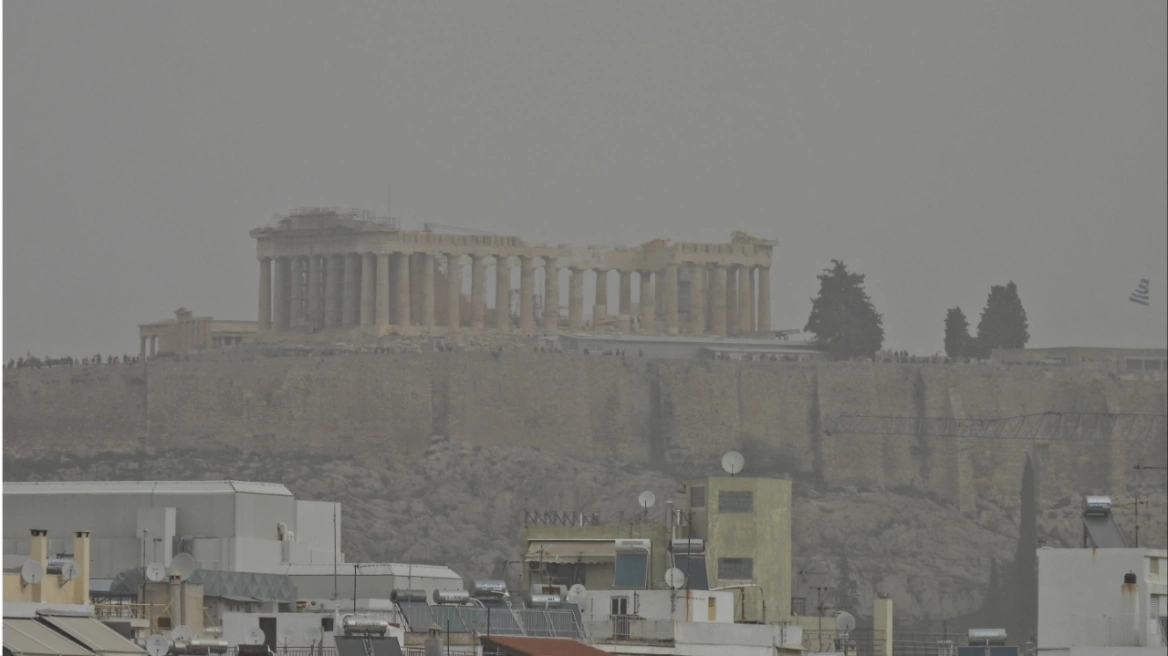
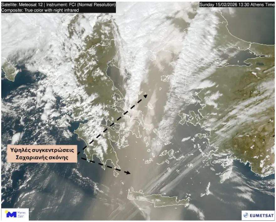
Saharan dust and gale-force gusts
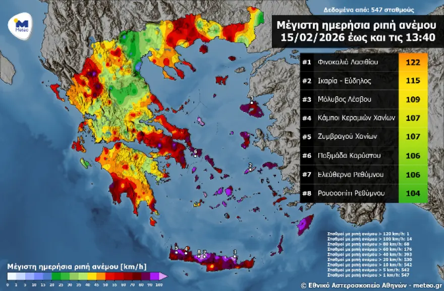
At midday Sunday, high concentrations of Saharan dust were recorded in Crete, while wind gusts in the eastern and southern parts of the island exceeded 100 km/h.
From Wednesday, a noticeable improvement in weather conditions is expected in most regions. For the coming weekend, the possibility of colder air masses descending from the Balkans is being considered, although this development has not yet been finalized.
High concentrations of Saharan dust were recorded across much of the country at midday Sunday 15/02, as seen in satellite imagery from the European MTG satellite of EUMETSAT.
According to the air quality station of the National Observatory of Athens / meteo.gr in Rethymno, PM10 concentrations exceeded 460 μg/m³ at 13:30 on Sunday 15/02.
At the same time, according to the network of automatic weather stations of the National Observatory of Athens / meteo.gr, strong wind gusts were recorded in much of eastern and southern Greece, locally exceeding 100–120 km/h.
How the phenomenon is explained
Dust transport: Strong southerly winds (“notiades”) over the Sahara and North Africa (Libya, Algeria) lifted large quantities of dust and sand, transporting them into the upper atmosphere over Greece.
Warm southerlies & heat: These winds originate from warm regions, causing a significant rise in temperature (up to 20°C in some areas).
Mud rain (wet deposition): When the dust wave met the low-pressure system that brought rainfall, the dust was “washed” out of the atmosphere and fell to the ground in the form of mud.
Affected areas: The phenomenon was intense in Crete, the Peloponnese, the Cyclades, Attica and the southern Aegean.
What follows: According to forecasts, after the “stifling” conditions, a new change in the weather is expected, with winds turning northerly, which will clear the atmosphere but bring a noticeable drop in temperature.
How significant was the dust transport episode of February 15, 2026?
According to measurements from the particle monitoring station operated by the METEO unit of the National Observatory of Athens in Rethymno, maximum concentrations reached 520 micrograms per cubic meter of air, a value assessed as particularly high. At the same time, mud rain occurred in many parts of the country, while dust also covered snow-covered surfaces of Greek mountains such as Kalavryta, Parnassos and Tymfi.
How many dust transport episodes have occurred so far in 2026?
Since January 1, 2026, and according to measurements from the METEO unit’s particle monitoring station in Rethymno, at least seven episodes have been recorded, two of which are considered very significant:
- 07/01/2026, with a maximum PM10 concentration of 100 μg/m³
- 21–22/01/2026, with a maximum PM10 concentration of 318 μg/m³
- 26/01/2026, with a maximum PM10 concentration of 271 μg/m³
- 29/01/2026, with a maximum PM10 concentration of 105 μg/m³
- 31/01–01/02/2026, with a maximum PM10 concentration of 434 μg/m³
- 05–07/02/2026, with a maximum PM10 concentration of 157 μg/m³
- 15/02/2026, with a maximum PM10 concentration of 520 μg/m³
How often do we see dust episodes in winter?
Although in our region most desert dust transport episodes occur in spring, events also appear during the winter months, but with much lower frequency. Significant dust episodes in the first two months of the year were recorded in January 2014, 2019 and 2021, as well as in February 2015.
How reliably do models predict dust transport in the Eastern Mediterranean?
Since 2015, the METEO Unit of the National Observatory of Athens has continuously contributed operational dust transport forecasts through the DUST/METEO model to the World Meteorological Organization’s Sand and Dust Storm Warning Advisory and Assessment System (SDS-WAS). This participation integrates the METEO Unit into a global network of operational centers providing dust forecasts and assessments.
In a recent independent scientific study*, the performance of 11 operational dust transport models, including DUST/METEO (NOA-WRF-CHEM), was evaluated on a large scale for the first time in predicting particulate concentrations, compared with actual measurements from stations in Cyprus, Greece (Finokalia, Crete) and Israel. Results show that model performance varies significantly depending on region and episode intensity. No model outperforms in all cases, but certain systems stand out for consistently good performance.
DUST/METEO, the regional dust forecast model developed and operated by the METEO Unit of the National Observatory of Athens, is ranked among the best-performing models in the study, particularly during intense dust episodes:
- In extreme episodes, it achieved the highest correlation of all models in Finokalia, Crete, accurately capturing the timing of strong events.
- In heavily affected regions such as Israel, DUST/METEO showed very good detection capability, with high correlations and competitive errors compared to international models.
- In the analysis of confirmed dust days, NOA-WRF consistently ranks among the top two models (out of 11 evaluated), alongside a corresponding model run by NASA.
The study also shows that NOA-WRF tends to better represent the temporal evolution and intensity of strong episodes, a particularly important feature for early warning systems and public health protection.
Weather today
Intermittent cloud cover with local showers is expected. During the evening hours and early morning of Tuesday 17/02, phenomena will intensify in the west with local thunderstorms, while snowfall is expected in the northwestern mountains. Elevated concentrations of Saharan dust are expected in the southeast, gradually decreasing significantly by the end of the day.
Temperatures will range from 0 to 12–13°C in Western Macedonia, 1 to 15°C in the rest of Macedonia and Thrace, 1 to 17°C in Thessaly, -1 to 14°C in Epirus, 4 to 16°C in the rest of the mainland, 9 to 13–15°C in the Ionian Islands, and 9 to 17–18°C in the Aegean islands and Crete.
In the Ionian Sea, northwesterly winds of up to 4–5 Beaufort are initially expected, gradually turning westerly from the afternoon with intensities of 5–6 Beaufort and a tendency to further strengthen in the early hours of Tuesday 17/02. In the Aegean, generally southwesterly/westerly winds of 4–5 and locally 6 Beaufort are expected.
In Attica, intermittent cloud cover is expected with a chance of local showers or thunderstorms around midday and early afternoon. Winds will initially blow from southerly directions at up to 4–5 Beaufort, turning westerly after midday at 3–4 Beaufort. Temperatures will range from 12 to 16°C.
In Thessaloniki, generally fair weather with intermittent clouds is expected. Winds will be variable at 2–3 Beaufort. Temperatures will range from 8 to 15–16°C.
Weather on Tuesday 17-02-2026
In eastern Central Greece, Evia, Thessaly and eastern Peloponnese, temporarily increased cloud cover with local rain and gradually isolated thunderstorms. In the rest of the country, increased cloudiness with rain and scattered thunderstorms initially in the west, north and eastern Aegean, gradually spreading elsewhere. Snowfall will occur in the mainland mountains, locally heavy in the mountains of Epirus and Macedonia. Phenomena, possibly locally strong in the west, will gradually weaken from the afternoon and from the northwest.
Winds in the west will blow westerly to southwesterly at 5–7 Beaufort, gradually turning northwesterly from late morning and reaching locally 8 Beaufort in the Ionian. In the east, westerly to southwesterly winds of 5–7 and locally 8 Beaufort in the southern Aegean, gradually turning westerly to northwesterly in the evening with the same intensity.
Temperatures will drop mainly in the north and west. Highs will reach 13–15°C in the north, 14–16°C in the west, 16–18°C in the rest of the country and locally 19°C in the Dodecanese, while in the northwestern mainland they will not exceed 9–11°C.
Weather on Wednesday 18-02-2026
In the northern and eastern Aegean islands, the Cyclades, the Dodecanese and possibly Thrace and Crete, cloudiness with local showers, scattered thunderstorms and improvement from midday. In the rest of the country, generally fair weather with a few clouds gradually increasing locally from the afternoon. Light snowfall will occur in the northern mountains in the morning.
Winds will blow westerly to northwesterly at 5–7 and locally 8 Beaufort at sea, quickly weakening from late morning.
Temperatures will drop slightly in the east.
Weather on Thursday 19-02-2026
In the west, a few clouds locally increased with local rain and from the afternoon in the northwest possibly isolated thunderstorms. In the rest of the country, a few clouds that will increase late at night in the eastern Aegean, where a few local showers are possible.
Winds will blow from southerly directions at 4–6 and from the afternoon locally 7 Beaufort at sea.
Temperatures will rise slightly.
Weather on Friday 20-02-2026
Initially in the west and the eastern Aegean and gradually in the rest of northern and central Greece, cloudiness with local rain. Scattered thunderstorms will initially occur in the northwest and gradually in the rest of the west, central and northern regions. Snowfall will occur from midday in the mountainous and semi-mountainous areas of Epirus, Macedonia and Thrace.
Winds will blow from southerly directions at 5–7 and locally 8 Beaufort at sea, gradually turning northerly in the west and north from the afternoon with the same intensity.
Temperatures will drop in the north.
Ask me anything
Explore related questions