
The new wave of severe weather began with thunderstorms in Attica, bringing heavy rains and storms to much of the country over the next three days, according to meteorologists.
Around 6:45 AM, flooding caused a traffic disruption at the underpass on Mesogeion Avenue at the Katehaki intersection. The road reopened shortly after 7:15 AM, though two vehicles remained stranded in the right lane due to breakdowns.
Meanwhile, the fire brigade received calls to pump water from areas including central Athens, Papagou, Filothei, and Holargos.
Διάσπαρτες οι καταιγίδες κυρίως στα νοτιότερα τμήματα της χώρας. Αξιόλογες οι βροχές ήδη σε Αργολίδα Σαρωνικό και Δυτικά τμήματα Αττικής. Το ίδιο τοπικά σε ΝΔ Πελ/σου και Κρήτη pic.twitter.com/XcKdesGQJP
— Theodoros Kolydas (@KolydasT) December 6, 2024
Meteorologist Panagiotis Giannopoulos explained on ERT that the storm in Attica primarily hit the northern suburbs, where the highest rainfall levels were recorded.
Traffic has been heavy on the Kifissos Avenue in both directions from Renti to Lykovrysi since early morning.
“The thunderstorms are scattered, mainly in the southern parts of the country. Notable rainfalls have already occurred in Argolida, the Saronic Gulf, and western Attica. Similarly, localized heavy rains have affected the southwestern Peloponnese and Crete,” wrote Theodore Kolydas, director of the Hellenic National Meteorological Service (HNMS), in a post on X (formerly Twitter) shortly before 3:00 AM Friday when rain began in Attica.
Ωρα 05:50 . Σε σταδιακή εξασθένηση οι καταιγίδες στην Αττική με κινηση Β-ΒΔ. Πάντως μέσα στο επόμενο δίωρο χρειάζεται προσοχή, καθώς σε τοπικό επίπεδο οι ραγδαιότητες είναι μεγάλες. Τα συνολικά ύψη βροχής στον αστικό ιστό προς το παρόν φτάνουν τα 20-30mm, . @EMY_HNMS… pic.twitter.com/KiAa0sxHp0
— Theodoros Kolydas (@KolydasT) December 6, 2024
In a subsequent post at 5:50 AM, Kolydas again warned about the storms in Attica and emphasized areas requiring caution:
“Storms in Attica are gradually weakening, moving north-northwest. However, over the next two hours, caution is needed due to high localized intensities, while total rainfall in the urban area does not exceed 20-30mm,” the HNMS director wrote.
? Η ΠΡΟΟΠΤΙΚΗ ΤΟΥ ΚΑΙΡΟΥ ΑΠΟ ΤΗΝ ΕΜΥ
— Theodoros Kolydas (@KolydasT) December 5, 2024
☑️Στις ακτές της Λιβύης βρίσκεται αύριο το πρωί τόσο το ανώτερο χαμηλό στα 500hPa, όσο και το επιφανειακό χαμηλό, όπως διακρίνουμε στον πρώτο χάρτη. Ο πολικός αεροχείμαρρος (jet stream) έχει μεταφέρει αρκετά νότια τις ασταθείς αέριες μάζες,… pic.twitter.com/m2Rxi2BLVE
Earlier, Kolydas had commented on the upcoming two-day storm, noting:
“By tomorrow morning, both the upper low-pressure system at 500hPa and the surface low will be positioned off the Libyan coast, as shown in the first chart. The polar jet stream has shifted unstable air masses significantly southward, passing south of Crete by Saturday. Rainfall over the next two days will be intermittently intense in the western, central, and southern coastal and maritime regions, but overall, precipitation levels won’t be exceptionally high. The heaviest rainfall is expected from midday Friday to midday Saturday. Notably, Rhodes is among the areas likely to be significantly impacted, with a prolonged period of effects accompanied by southeastern winds.”
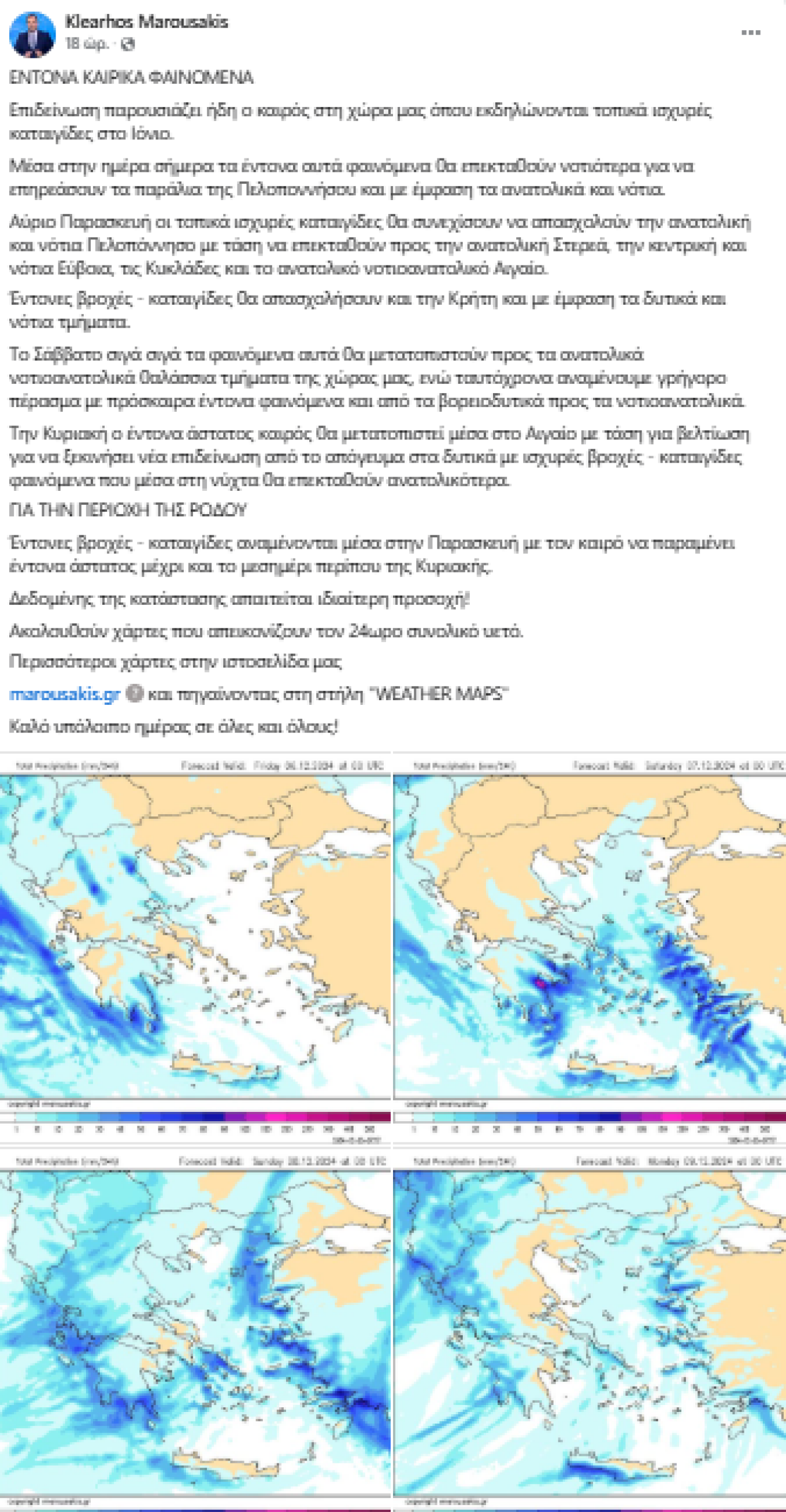
According to meteorologist Klearchos Marousakis, the storm will initially strike the southern and eastern Peloponnese, with intense phenomena expected in Messinia, Laconia, Arcadia, and Argolida. Significant volumes of rain are forecasted in these regions through Friday morning. The phenomena will then shift toward the Cyclades and the southeastern Aegean, continuing through Sunday. Particular attention is required for Rhodes, which was recently devastated by Storm Bora, causing extensive damage last weekend.
Significant Local Rainfalls Yesterday in Mainland and Ionian Regions
Localized rainfalls and storms occurred on Thursday, December 5, in several mainland areas and the Ionian Sea. According to data from the automatic weather station network of meteo.gr / National Observatory of Athens, the highest recorded rainfall as of 12:00 PM Thursday was 53 mm at the meteorological station in Zakynthos. The table below lists the top eight rainfall measurements recorded by the network up to 12:00 PM on December 5.
Today’s Weather Forecast
Localized rain showers and thunderstorms are expected primarily in the Ionian Sea, the central and southern mainland, the Aegean, and later in the afternoon in Thrace. These phenomena may be more prolonged and intense in parts of the Eastern Aegean and the Dodecanese.
Temperature:
- Western Macedonia: -1°C to 10°C
- Rest of Northern Greece: -2°C to 12-13°C
- Thessaly: 2°C to 13°C
- Epirus: 1°C to 16-17°C
- Remaining mainland areas: 3°C to 17-18°C
- Ionian Islands: 10°C to 17°C
- Northern Aegean Islands: 5°C to 11°C
- Other Aegean Islands and Crete: 10°C to 18-19°C
Winds:
- Central and Southern Aegean: Predominantly southeast winds, initially reaching 5 to locally 6 Beaufort, gradually weakening.
- Northern Aegean: Winds from various directions, reaching 4 to locally 5 Beaufort.
- Ionian Sea: Generally southeast winds, initially reaching 5 to locally 6 Beaufort, gradually decreasing to 3-4 Beaufort.
Ask me anything
Explore related questions