
A small “break” is expected today from the storm Elena, which caused significant issues in Attica and Evia. However, starting tomorrow, the weather is expected to worsen again, bringing a further drop in temperatures, stronger northerly winds, and snowfall, even in Attica.
According to meteorologists, many areas of the country are expected to be “dressed in white” over the weekend, particularly Magnesia, Evia, eastern Central Greece, and northern parts of Attica, including Parnitha and Penteli.
Specifically, Klearchos Marousakis noted that the ongoing weather front will gradually recede, offering a brief respite today. However, over the weekend, a new cold front will arrive from Ukraine, carrying a polar air mass.
As a result, snow will fall in the eastern regions of the country, though the weather is expected to become milder by Monday. It will also remain mild on New Year’s Day.
In his post, the OPEN meteorologist stated:
“UKRAINIAN SNOWFALL THIS WEEKEND”
“Another deterioration in the weather is expected from Friday night, again affecting areas from the latitude of Halkidiki southward and east of the Pindus mountain range.
The cause of this development is a new disturbance originating from Ukraine, which, as seen in the map with the letter ‘X’ and deep blue shading, will move south-southwest, entering the Aegean Sea.
This time, in addition to rain, thunderstorms, and snow in mountainous and semi-mountainous areas, we may see heavy snowfalls and snowstorms even at very low altitudes.
Evia will be at the ‘epicenter’ of this snowstorm, as will the northeastern Aegean islands, albeit briefly. Following Evia, regions at high risk include eastern and southern Thessaly, Attica-Boeotia, the mountainous and semi-mountainous areas of the Peloponnese, and even the mountains of Crete (concerning snowfalls).
FOR ATTICA
Heavy snowfall is expected in all mountainous and semi-mountainous areas, with an increased likelihood of snow reaching lower altitudes in the northern parts of the region.
Snowstorms are also quite likely!
The expected disturbance will be strongly supported aloft by an organized polar air mass. As this mass passes over the warmer Aegean Sea, it will generate intense instability.
Due to low atmospheric temperatures, snowstorms—dense snowfall accompanied by lightning (thunder and lightning)—are quite possible. This phenomenon could lead to rapid snow accumulation even if surface temperatures are not particularly favorable.”
According to Theodoros Kolydas and Yiannis Kallianos, snowfall on Saturday will occur at lower altitudes, including in Attica.
Specifically, for Attica, Yiannis Kallianos mentioned that snow is expected in:
- Dionysos
- Varnavas
- Hippocrates’ State
- Vilia
- Thrakomakedones
Theodoros Kolydas identified the areas most affected by intense phenomena on Saturday as:
- Magnesia
- Evia
- Eastern Central Greece
- Northern Attica, with snowfall in Parnitha and Penteli
Yiannis Kallianos also mentioned that on Saturday, December 28, the weather will worsen from Pelion southward, with heavy snowfalls expected at altitudes of 500 meters and above, affecting:
- Eastern Thessaly
- Southern Thessaly
- Attica
- Boeotia
- Phthiotis
- Evia
- Northeastern Peloponnese
The meteorologist added that Evia and possibly parts of Attica may experience snowstorms.
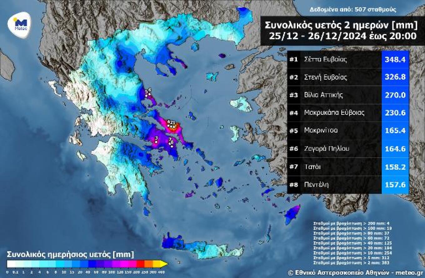
Extremely High Rainfall in Attica and Evia Over the Two-Day Period of December 25–26
Significant amounts of rainfall have been recorded (and continue to be recorded) in Evia (especially central parts), Magnesia, Mount Athos, the Dodecanese, and Attica over December 25–26, 2024. In some locations, rainfall exceeded 200–300 mm.
The following map shows total rainfall levels for December 25–26 (up to 8:00 PM), as recorded by 507 meteorological stations of the National Observatory of Athens/meteo.gr network. The top eight highest rainfall measurements are also highlighted. The highest rainfall level was recorded in Setta, Evia, at 348.4 mm.
Today’s Weather
Rain is expected in the eastern and southern mainland, Evia, the Sporades, the Cyclades, Crete, and the Dodecanese. Thunderstorms, particularly in Crete and the Dodecanese, may be locally intense. Snowfall is expected in the mountains of these regions, especially in Magnesia, Evia, and Crete. Conditions will temporarily improve, with phenomena limited to Crete. However, a new weather deterioration is expected in the afternoon from the northeast, bringing rain to lowlands, snow to mountainous and semi-mountainous areas, and even some plains in Thrace. By the end of the day, most central and eastern regions will experience snowfall, mainly in mountainous and semi-mountainous areas.
Temperatures
- Western Macedonia: -6 to 3°C
- Northern Greece: -2 to 6–8°C
- Thessaly and Northeastern Sterea: 0 to 10°C
- Epirus: 3 to 12–13°C
- Other mainland areas: 2 to 11–13°C
- Ionian Islands: 6 to 14°C
- Northern Aegean Islands and Sporades: 5 to 10°C
- Southern Aegean Islands and Crete: 7 to 12–14°C
Winds
- Aegean: Northeasterly winds at 6–7 Beaufort, occasionally reaching 8 Beaufort.
- Ionian: Initially northeasterly winds up to 6 Beaufort, turning easterly by evening with similar intensities.
For Attica
Rain and snow are expected in Parnitha and Kithaironas, though conditions will improve temporarily in the morning. Another deterioration is expected in the evening, with rain in lowlands and snow in mountainous areas. By Friday night into Saturday, snow may also fall in semi-mountainous areas. Northeasterly winds will reach 5–6 Beaufort. Temperatures will range from 6 to 10°C but will drop at night.
For Thessaloniki
Partly cloudy initially, with increasing cloud cover by the afternoon. Snowfall is possible in mountainous and semi-mountainous areas during the evening. Northerly-northwesterly winds at 3–5 Beaufort. Temperatures will range from 1 to 6°C.
Saturday’s Weather (December 28, 2024)
In eastern Macedonia, Thrace, Halkidiki, eastern Thessaly, central and eastern Sterea, eastern and southern Peloponnese, and the Aegean, expect temporary heavy cloud cover with localized rain or sleet, and thunderstorms in southeastern Aegean regions. Snow will fall in mountainous and semi-mountainous areas of mainland Greece, northern Aegean islands, and Crete, occasionally dense in eastern Thessaly, eastern Sterea, and Evia. Gradually, phenomena in the northern mainland and other regions will subside, with clearer skies expected later.
Winds
- Western regions: Northeasterly winds at 4–6 Beaufort, weakening by noon.
- Eastern regions: Northerly winds at 5–7 Beaufort, locally reaching 8–9 Beaufort in the Aegean.
Temperatures
- Slight drop in most areas.
- Northern regions: 6–8°C max.
- Central and eastern mainland: 9–11°C max.
- Aegean: 11–13°C max.
- Western regions: Up to 14°C.
- Frost expected in inland areas during morning and evening hours.
The Weather on Sunday, December 29, 2024
In eastern Macedonia, Thrace, Halkidiki, eastern Thessaly, eastern Central Greece, eastern Peloponnese, and the Aegean, the weather will feature periods of increased cloudiness with localized rain, primarily in the Aegean, where thunderstorms will occur in the southeastern areas until the morning hours. Snowfall is expected in the mountainous regions of Crete. Elsewhere in the country, the weather will generally be clear with occasional local clouds.
Winds in the west will be variable at 3 to 4 Beaufort. In the east, winds will blow from the north at 5 to 7 Beaufort, reaching 8 Beaufort in the Aegean during the morning hours, gradually weakening throughout the day.
Temperatures will see a slight increase in maximum values, especially in western areas. Frost will occur in mainland areas during the early morning hours.
The Weather on Monday, December 30, 2024
The weather will generally be clear across most regions, with occasional local clouds. In the Cyclades and Crete, there will be cloud cover with localized rainfall until the afternoon. Visibility will be locally reduced in the west, central, and northern parts of the country during the early morning and evening hours.
Winds in the west, central, and northern areas will be variable at 3 to 4 Beaufort. In the remaining areas, winds will blow from the north at 4 to 5 Beaufort, reaching 5 to 6 Beaufort in the Aegean and 6 to 7 Beaufort in its southeastern parts.
Temperatures will rise, though frost will still occur locally in central and northern mainland areas during the early morning hours.
The Weather on Tuesday (New Year’s Eve), December 31, 2024
The weather will be predominantly clear. Visibility in the Ionian and mainland regions will be locally reduced during the early morning and evening hours.
Winds will be variable at 2 to 4 Beaufort, while in the Aegean, they will blow from the north at 4 to 5 Beaufort, reaching up to 6 Beaufort in the southeastern areas during the morning hours.
Temperatures will rise further, though frost will persist locally in the northern mainland during the early morning hours.
Ask me anything
Explore related questions