
Mild weather will continue over the weekend in most parts of the country, except the Aegean islands, eastern Crete, and the Dodecanese, where localized showers will occur. At the same time, local fog is expected in several areas in the early morning and late evening, while the temperature will rise again.
More rain is expected towards the end of the month from the northwest, while as for the new cold wave in early February, the director of EMY, citing relevant maps, responds to colleagues’ forecasts.
“From the internet, space is cultivating false hopes and “news” for much-needed snowfalls, but the uncertainties are great and the forecast horizon is limited,” writes Thodoris Kolydas about the cold weather expected in the country.
For his part, meteorologist Sakis Arnaoutoglou insists that “after February 2 and 3 there are indications of winter-type downturns something that we will see in the next few days how our country will be affected” and responds to those who contradict him. “They don’t affect me, I hope it’s not too late for climate change.
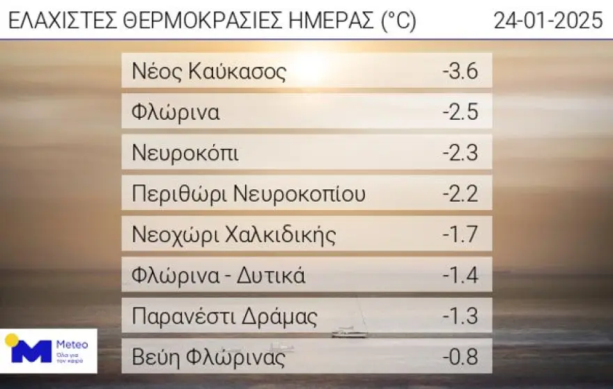
Frost in the north on Friday morning 24/01/2025
Frost occurred in the morning of Friday 24/01 in the northern continental parts, with the lowest minimum temperature recorded in the New Caucasus of Florina at -3.6°C.
According to the network of automatic weather stations of the National Observatory of Athens / meteo.gr, the eight lowest minimum temperatures during the morning hours of Friday 24/01 are presented in the following Table.
Today’s weather
A few clouds are forecasted, partly cloudy, with the possibility of local rain in the morning hours on the islands of the East Aegean and the Dodecanese. In the evening, rainfall in the Dodecanese will be locally heavy. In the morning hours on the mainland, visibility will be limited in places and there will be fog, while frost will occur in the northern mainland.
The temperature will range from -1 to 15 degrees in Northern Greece (in Western Macedonia from -3 to 12 degrees), 3 to 18 degrees in Central and Southern Greece, 6 to 18 degrees in Western Greece (in Epirus from 2 to 14 degrees), 8 to 17 degrees in the Cyclades and from 7 to 20 degrees in Crete, 6 to 16 degrees in the East Aegean islands and from 10 to 17 degrees in the Dodecanese.
The winds will blow initially in the Aegean and the Ionian Sea from variable directions, light and moderate noon to strong 5-6 Beaufort, from northeastern directions in the Aegean and northwestern directions in the Ionian Sea.
Thin clouds at times thicker and with limited visibility in some places in the morning and evening hours are expected on Friday in Attica. The temperature will range from 8 to 17 degrees Celsius, but in the north, it will be 2-3 degrees lower. The winds will blow initially in the morning from variable directions, light, and after noon almost moderate 4 Beaufort from northeastern directions.
A few clouds, occasionally increasing and local fog in the morning and evening hours are expected on Friday in Thessaloniki. The temperature will range from 5 to 14 degrees Celsius. The winds in Thermaikos will blow from variable directions, light.
The weather on Sunday 26-01-2025
In Crete, the eastern parts of the Cyclades and the Dodecanese a few clouds, partly increasing in the morning hours with local rain and in the Dodecanese possibly isolated thunderstorms.
In the rest of the country, initially generally clear weather with thin clouds in the west, which will gradually become thicker and expand to the rest of the country. Local showers will occur from midday in the Ionian and western Peloponnese. Visibility in the morning and evening hours on the mainland will be limited in places.
Winds in the west and north will be variable 3 to 4 Beaufort and in the rest of the country will blow from the north 3 to 5 and in the Aegean Sea locally 6 Beaufort with gradual weakening.
The temperature will drop slightly, mainly in the north. It will reach 13 to 14 degrees Celsius in the north, 15 to 16 degrees Celsius in the central and eastern mainland, 17 to 18 degrees Celsius in the rest of the country, and 19 degrees Celsius locally in the Dodecanese.
The weather on Monday 27-01-2025
hourly 20-20-20-20-20-20 on Monday, October 20-20-20-20, 20/20/20-20.
Thin clouds in places and at times more dense with the possibility of light local rain in the west. Visibility in the morning and evening hours will be limited in places and fog is likely to form on the mainland.
Winds will be variable from 3 to 4 Beaufort.
The temperature will rise slightly.
The weather on Tuesday 28-01-2025
Across the country, a few clouds are forecasted, increasing in places and at times with light local rain in the west, the Cyclades, Crete, the islands of the eastern Aegean and the Dodecanese. Visibility in the morning and evening hours will be limited in some places and the mainland fog may form.
The winds will blow from southern directions 3 to 4 and in the sea locally 5, occasionally in the north up to 6 Beaufort.
The temperature will rise slightly further, mainly in the south.
The weather on Wednesday 29-01-2025
In the northwest, increasing clouds with showers and occasional thunderstorms. In the rest of the country a few clouds, occasionally increasing in places, with a possibility of light local rain mainly in the eastern Aegean islands and the Dodecanese. Visibility in the morning and evening hours will be limited in places.
Winds in the west will blow from southern directions 3 to 5 and in the sea locally 6 Beaufort.
The temperature will not change significantly.
Ask me anything
Explore related questions