
The weather pattern is expected to change from today, with temperatures dropping, strong north winds intensifying, and localized showers anticipated in eastern and southern regions, as well as in the mountainous areas of western Greece during the warmer hours of the day.
Μεταβολή του καιρού και προσοχή σε δυτική Ελλάδα από το απόγευμα του Σαββάτου και την Κυριακή, κυρίως σε Νομούς Μεσσηνίας Ηλείας και Αχαίας. Προσοχή σε δυτική Στερεά καθώς και σε Ζάκυνθο Κεφαλονιά . Η Αθήνα δεν επηρεάζεται σημαντικά – Ίσως και καθόλου . Γεγονός είναι οτι από… pic.twitter.com/APjoCFWk8C
— Theodoros Kolydas (@KolydasT) September 25, 2025
According to STAR meteorologist and former director of the National Weather Service, Thodoris Kolydas, the real shift will come over the weekend. He warns of unstable weather and dangerous conditions, particularly in western Greece:
-
From Saturday afternoon and throughout Sunday, heavy rain and storms may affect Messinia, Ilia, and Achaia.
-
Western Sterea, Zakynthos, and Kefalonia are also at risk.
-
Athens, however, is expected to remain largely unaffected.
“From Sunday onwards, the weather will turn autumnal,” Kolydas explains. “Temperatures will drop by about 5 degrees and the sense of cold will be intensified by strong northerly winds.” Winds in the Aegean are forecast to reach 7–8 Beaufort on Friday, easing slightly from Saturday afternoon.
Meteorologists Warn of “Extremely Dangerous Weather”
Forecast maps published by meteorologist Klearchos Marousakis highlight the Ionian Islands, western Greece, and the Peloponnese as the regions most likely to be affected by the upcoming wave of bad weather.
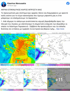
He warns of multi-hour feedback storms west of the Pindos mountains, capable of producing extremely high rainfall and significantly increasing flood risk. The storms are expected to last more than 24 hours as they remain locked in place by the expected barometric system.
Meteorologist Giorgos Tsatrafyllias also issued warnings, noting two “lines of danger”:
-
First line (highest risk): Ilia, Achaia, Messinia, Zakynthos
-
Second line: Kefalonia–Ithaca, Arcadia, Aitoloakarnania
He added that coastal shipping could be disrupted, especially in the central and northern Aegean on Friday and Saturday, while temperatures will drop by 6–8°C from Saturday onward.
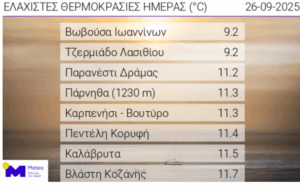
Thursday’s Coldest Spots
Crete recorded the lowest temperatures on Thursday morning, with Tzermiado (Lassithi) dropping to 5.1°C. Other single-digit temperatures were measured in central and northern Greece as well as in mountain plateaus.
The absolute minimum was recorded at Sesi Parnassos with -3.8°C.
Detailed Forecast
Thursday, Sept. 25
-
Clouds with localized showers in Thessaly, Central & Eastern Sterea, Evia, Eastern Peloponnese, and Northern Crete.
-
Sunshine elsewhere, with local rain in Epirus, Western Macedonia, and parts of the Peloponnese.
-
Temperatures:
-
Northern Greece: 14–26°C (12–22°C in Western Macedonia)
-
Central/Southern Greece: 17–25°C (up to 27°C in Thessaly)
-
Western Greece: 17–30°C
-
Cyclades & Crete: 19–25°C
-
East Aegean & Dodecanese: 19–28°C
-
-
Winds: North 5–6 Beaufort in the Aegean, locally 7 Beaufort (gusts 80–90 km/h). Light to moderate in the Ionian.
Friday, Sept. 26
-
Attica: Sunshine with increasing clouds in the north/east. Temperatures 18–25°C, 2–3°C lower in the north/east. Northerly winds 4–5 Beaufort, up to 6–7 Beaufort in the east.
-
Thessaloniki: Few clouds, locally denser. Temperatures 18–24°C.
Saturday, Sept. 27
-
Scattered clouds across the mainland and Crete, with local showers.
-
From afternoon: rain and thunderstorms intensify in the west, especially the Ionian and western Peloponnese at night.
-
Winds: SE 3–5 Beaufort in the west, N 4–6 Beaufort in the east, Aegean 6–7 Beaufort (up to 8 early).
-
Temperatures: 24–25°C north, 26–27°C west/Dodecanese, 25–26°C elsewhere.
Sunday, Sept. 28
-
Cloudy in most regions, with local showers and storms, especially in the Ionian and mainland.
-
Western Peloponnese may see intense phenomena until the afternoon.
-
Winds: South in the west, north in the east 4–5 Beaufort, up to 6 in the Aegean.
-
Temperatures: Slight further drop.
Ask me anything
Explore related questions


