A significant deterioration in the weather is expected from today as a deep low-pressure system moves from the Gulf of Sirte northeastward, bringing heavy rain and thunderstorms, as well as snowfall even at lower elevations, according to the Hellenic National Meteorological Service (EMY) and METEO of the National Observatory of Athens. At the same time, 112 emergency alerts have already been sent to areas of the Peloponnese advising residents to limit travel.
Where the most severe phenomena will hit today
According to forecast data from METEO/EAA, during the course of the day (21/1) rain and thunderstorms will be locally strong from midday in the Eastern and Southern Peloponnese, from the afternoon in Eastern Central Greece (including Attica), Thessaly, Evia, and the Sporades, while from the evening the phenomena will also spread to the Cyclades. At the same time, METEO notes that based on the Rainfall Potential Index (RPI), Wednesday’s episode is classified as Category 5 (extreme).
In addition, METEO/EAA points out that the following should be taken into account:
- Heavy snowfall in mountainous and semi-mountainous areas of mainland Greece and the Northern Aegean, as well as in lower-altitude areas of Western and Central Macedonia, Thessaly, and temporarily Eastern Macedonia and Thrace.
- Large volumes of rainfall expected mainly in the Eastern and Southern Peloponnese, Central and Eastern Central Greece, Evia, and Eastern and Southern Thessaly.
- Gale-force winds in western and southern areas.
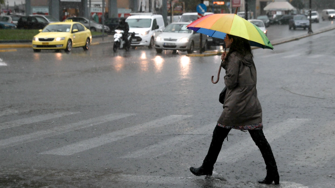
Athens and Attica: rain from the morning, intensifying in the afternoon
For Attica and Athens, rain is forecast from early morning, intensifying from the afternoon, with heavy rain and thunderstorms.
Emphasis, as highlighted by meteorological assessments, is placed on the intensity of rainfall over a short period of time, which is critical for the occurrence of local problems, especially in urban environments.
Snow even at low altitudes – Where caution is needed
Particular caution is also required due to snowfall expected in mountainous and semi-mountainous areas of mainland Greece and the Northern Aegean, as well as at lower elevations in Western and Central Macedonia, Thessaly, and temporarily Eastern Macedonia and Thrace. At the same time, gale-force winds will prevail in western and southern regions.
Sailing ban
Ships will remain in port today, Wednesday, due to adverse weather conditions.
From the port of Piraeus, all ferry routes to the Aegean islands, the Cyclades, and Crete have been canceled until 20:00. Toward the Saronic Gulf, no high-speed vessels will operate at least until 17:00. At the same time, all scheduled sailings from the ports of Rafina and Lavrio have been canceled.
Sailing ban in the Ionian Sea
The competent authorities have also imposed a sailing ban in the Ionian Sea due to gale-force winds.
Passengers are advised to contact ferry companies and follow official announcements for updates regarding the lifting of the ban and the resumption of routes.
Rio–Antirrio ferry suspended – restrictions on the bridge
The Rio–Antirrio ferry service is suspended, while traffic restrictions are also in force on the bridge due to adverse marine conditions.
Specifically, according to “Gefyra” S.A., passage is prohibited for pedestrians, two-wheelers, caravans, and empty high-sided vehicles due to strong winds.
Kolydas: Caution in interpreting rainfall maps
Meteorologist Thodoris Kolydas notes that forecast models do not contradict one another, but rather offer different “perspectives” on the same phenomenon.
As he explains, the European ECMWF model shows a generalized winter weather episode with moderate and relatively uniform rainfall totals of around 20–30 millimeters, while the BOLAM model highlights local intensifications that could reach 30–40 millimeters. He notes, however, that even such amounts can cause problems in urban areas such as Athens when they fall over a short period of time.
Marousakis: Intense but seasonally normal bad weather
Meteorologist Klearchos Marousakis stresses that this is an intense but not unusual or extreme weather event for the season.
He explains that very cold air masses in the lower layers of the atmosphere inhibit the development of extreme thunderstorms over land, resulting in rainfall characterized more by duration than intensity. Thunderstorms are expected mainly over marine areas, while in Attica total rainfall of 50 to 70 millimeters is estimated locally, with peaks mainly from midday to afternoon.
Karpenisi blanketed in snow – reports of snowfall near Lake Plastira
Karpenisi has been blanketed in snow, as snowfall has been recorded since the early morning hours in mountainous areas of the country, while reports also indicate snow in the wider area of Lake Plastira in Karditsa.
The weather scene resembles full winter in several mountainous regions of Greece, with Karpenisi at the center of the storm. The city and surrounding highlands are covered in snow, temperatures remain low, and the cold is keenly felt.
Snowfall or sleet is also being recorded around Lake Plastira, where temperatures are hovering near zero, creating wintry conditions. Local authorities are monitoring developments, while drivers are urged to exercise particular caution on the road network, especially at higher elevations.
The cold front affecting the country is expected to maintain low temperatures and wintery conditions, with the possibility of further snowfall in mountainous and semi-mountainous parts of Central Greece and Thessaly in the coming hours.
112 alerts in the Peloponnese advising limited travel
An emergency message via 112 was sent to residents of Argolida and Corinthia, urging them to limit travel to absolutely necessary journeys due to severe weather expected from early morning until late afternoon.
Specifically, the messages state:
“Due to severe weather phenomena expected in the Regional Units of Argolida and Corinthia from early morning until late afternoon on Wednesday, limit your movements to those absolutely necessary. Follow the instructions of the authorities.”
State apparatus on full alert – Interministerial meeting and decisions
An extraordinary interministerial coordination meeting was convened by the Minister for Climate Crisis and Civil Protection, Giannis Kefalogiannis, with the participation of all competent ministries, Civil Protection agencies, regional governors, and representatives of local authorities, following a session of the Scientific Risk Assessment Committee.
The minister stressed the need for heightened vigilance, full operational readiness, and uninterrupted communication with the National Civil Protection Operations Coordination Center (ESKEDIK) throughout the duration of the event.
Among the decisions taken were: placing the Fire Service on alert, with general alert status in Attica and the deployment of EMAK and EMODE forces; heightened readiness of the Armed Forces, Hellenic Police, and Coast Guard; readiness of regional authorities, DEDDIE, ADMIE, EYDAP, EKAV, motorway concessionaires, and relevant ministries.
Giannis Kefalogiannis recalled that EMY has issued an emergency bulletin of dangerous weather phenomena, with a Red Code in the Peloponnese, Central Greece, Attica, Thessaly, and Western Macedonia, while an orange alert applies to other areas. He also urged citizens to strictly follow Civil Protection instructions, noting that the use of snow chains is mandatory in areas experiencing snowfall.
Today’s weather
Local rain is forecast across most of the country, with thunderstorms in western, central, and southern mainland areas, the Sporades, Evia, and the Cyclades. These will be locally strong in Eastern and Southern Peloponnese, Eastern Central Greece, Thessaly, Evia, the Sporades, and in the evening in the Cyclades. Snowfall will occur in mountainous and semi-mountainous areas of mainland Greece and the Northern Aegean, as well as in lowland areas of Thessaly, Western and Central Macedonia, and temporarily light snowfall at low elevations in Eastern Macedonia and Thrace. Snowfall is also forecast in the mountains of Evia and the Sporades.
Temperatures will range from -4 to 0°C in Western Macedonia; -3 to 6°C in the rest of Macedonia; -5 to 6°C in Thrace; 0 to 8°C in Epirus; 1 to 8°C in Thessaly; 4 to 11°C in Central Greece; 1 to 11°C in the Peloponnese; 7 to 10°C in the Ionian Islands; 2 to 7°C in the Northern Aegean islands; 10 to 15°C in the remaining Aegean islands; 11 to 13°C in the Dodecanese; and 11 to 16°C in Crete.
Winds will blow from easterly directions in the west at 6–8 Beaufort, weakening from midday. In the east, winds will be easterly to northeasterly at 4–6 Beaufort, and in the south and southeast southerly to southeasterly at 6–8 Beaufort.
In Attica, rain and locally strong thunderstorms are expected from midday, with snowfall in the mountains. Winds will be northeasterly, gradually turning southeasterly at 4–6 Beaufort and up to 7 Beaufort in southern areas. Temperatures will range from 4 to 12°C.
In Thessaloniki, local rain or sleet is expected, with snowfall in mountainous and semi-mountainous areas. Winds will be northwesterly at 2–4 Beaufort and up to 5 Beaufort in the Thermaic Gulf. Temperatures will range from -1 to 5°C.
Weather on Thursday, 22-01-2026
In western areas, the Cyclades, Crete, the Dodecanese, the islands of the northern and eastern Aegean, and temporarily in Eastern Macedonia and Thrace, cloudiness with rain and scattered thunderstorms is expected. The phenomena will be strong in the northern and eastern Aegean islands until late morning and in the Dodecanese until midday. In the rest of the country, temporarily increased cloudiness with local rain and isolated thunderstorms. Temporary snowfall will occur in mountainous areas of central and northern mainland Greece.
Winds will be southerly to southwesterly at 4–6 Beaufort, but until midday in the eastern Aegean islands and the Dodecanese they will be southeasterly at 7–9 Beaufort.
Temperatures will rise slightly in northern and central mainland areas, reaching 9–10°C in the north, 12–15°C elsewhere, and 17–18°C — locally up to 19°C — in Crete, the Cyclades, and the Dodecanese.
Weather on Friday, 23-01-2026
In western areas and the southern and eastern Aegean, increased cloudiness with rain and scattered thunderstorms. In the rest of the country, a few clouds temporarily increasing with local rain mainly in central and southern areas. Snowfall will occur in mountainous areas of northern mainland Greece.
Winds will be southerly to southwesterly at 4–5 Beaufort, locally up to 6 Beaufort.
Temperatures will rise slightly.
Weather on Saturday, 24-01-2026
In western and southern areas and the eastern Aegean, increased cloudiness with rain and scattered thunderstorms, mainly in marine and coastal areas. Elsewhere, a few clouds temporarily increasing with local rain mainly in central and northern regions. Light snowfall will occur in the mountains of Epirus and Western Macedonia.
Winds will be southerly to southwesterly at 4–5 Beaufort, locally up to 6 Beaufort, with a tendency to strengthen from the evening.
Temperatures will show no significant change.
Weather on Sunday, 25-01-2026
Initially in western, northern, and eastern Aegean areas, and gradually across almost the entire country, increased cloudiness with rain and scattered thunderstorms, possibly locally strong in the northwest. Snowfall will occur in central and northern mountainous areas.
Winds will be southerly to southwesterly at 5–7 Beaufort, locally up to 8 Beaufort at sea.
Temperatures will rise slightly.
Ask me anything
Explore related questions


