Severe weather is in full progress and today mainly affects Crete and the eastern regions, while the General Secretariat for Civil Protection has placed the Region of Crete under a “Red Code” state of mobilization. In the coming days, weather conditions will intensify with two more waves of bad weather, according to meteorologists.
Forecast and Civil Protection mobilization
The Hellenic National Meteorological Service (EMY) issued an Emergency Weather Deterioration Bulletin, which reports intense weather phenomena for today, Tuesday, and tomorrow, Wednesday, with heavy rain and storms affecting western Greece, eastern Macedonia, Thrace, the eastern Aegean, and Crete.
The General Secretariat for Civil Protection has placed Crete under “Red Code” status, calling on local authorities and municipalities to take measures to address possible flooding phenomena.
Tsatrafyllias: Three waves of bad weather this week
Meteorologist Giorgos Tsatrafyllias, in a post, stresses that the first wave of bad weather has already begun and is affecting the eastern regions of the country, with phenomena shifting to Crete and the Dodecanese.
According to his forecast, the next wave of bad weather is expected to affect the country from Wednesday to Thursday and the third wave from Saturday to Sunday. Heavy rain is expected, particularly in areas of western Greece and the eastern Aegean, as well as strong winds, with their intensity reaching 8 Beaufort.
Attica and other regions
In Attica, rainfall will be limited on Tuesday, with greater intensity expected on Thursday. Temperatures in the region will reach 15–16 degrees Celsius. Winds in Attica will remain weak, with easterly and southeasterly winds prevailing.
The latest forecast data for February show that the month will begin with mild weather, with temperatures remaining higher than normal levels, and without particularly cold conditions expected.
More than 43,000 electrical discharges on Monday, January 26
Heavy rain and storms occurred on Monday, 26/01, in many areas of the country.
More specifically, a large number of storms and electrical discharges were recorded mainly in marine, island, and coastal areas. According to data from the Lightning Imager (LI) instrument of the Meteosat-12 meteorological satellite, from the beginning of the 24-hour period until 17:30 Greek time, a total of 43,295 electrical discharges were recorded, of which 5,644 over land and 37,651 over the sea.
Electrical discharges are defined as the total of these, which include lightning (discharges between clouds and ground), electrical discharges between clouds, as well as electrical discharges between clouds and the surrounding air. In the map of Figure 1, the electrical discharges recorded by the LI instrument until 17:30 on Monday 26/01 are presented.
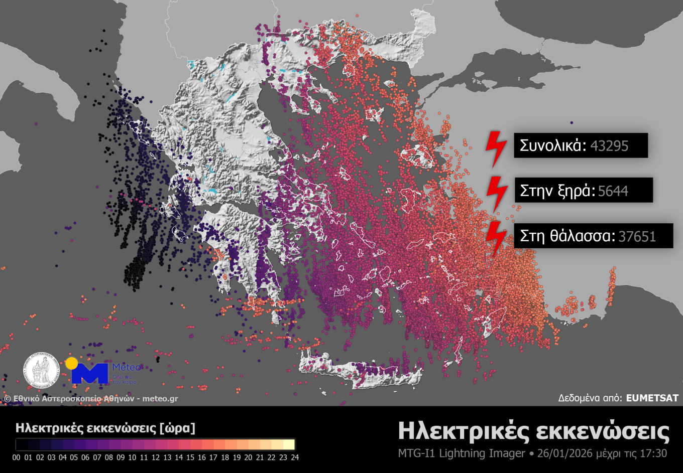
Figure 1. The electrical discharges recorded by the LI instrument until 17:30 on Monday 26/01
Regarding cumulative rainfall totals, and according to records from the network of automatic meteorological stations of meteo.gr / National Observatory of Athens, these exceeded 100 millimetres in Eastern Macedonia (Volakas Nevrokopi – 154 millimetres) and in the Peloponnese (Sparta – 114 millimetres). In the map of Figure 2, the distribution of rainfall and the 8 stations with the highest rainfall totals until 17:40 on Monday 26/01 are presented.
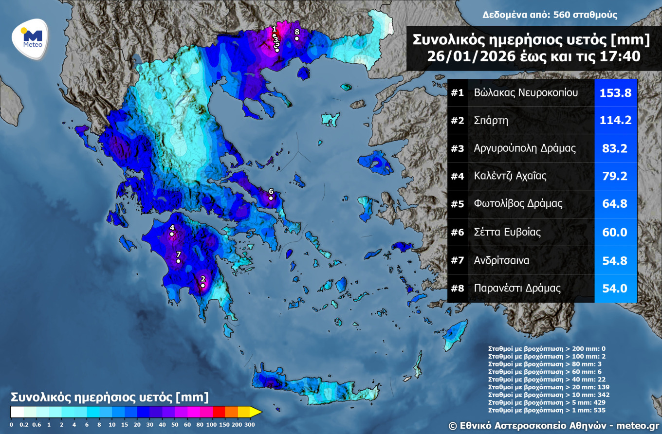
Figure 2. Distribution of rainfall and the 8 stations with the highest rainfall totals until 17:40 on Monday 26/01
The weather today
Rain and storms are expected, which will gradually be limited to the eastern parts of the country and from the afternoon to the Eastern Aegean, the Dodecanese, and the mountainous areas of Crete and the Peloponnese. Snowfall will occur in the northwestern mountainous areas until midday. Dust concentrations will be increased in the southeastern regions.
Temperatures will range from 0 to 8 degrees Celsius in Western Macedonia, from 4 to 13 in the rest of Macedonia and Thrace, from 6 to 14 in Thessaly, from 2 to 13 in Epirus, from 5 to 16 in Central Greece and the Peloponnese, from 7 to 13 in the Ionian Islands, from 7 to 14 in the islands of the Northern and Eastern Aegean, from 10 to 14 in the Cyclades, from 11 to 15 in the Dodecanese, and from 10 to 18 degrees Celsius in Crete. It is noted that in Epirus, Macedonia, Thrace, and the Northern Aegean, the minimum temperature is expected toward the end of the 24-hour period.
Winds in the Aegean will initially blow from southwestern directions at 5 to 7 Beaufort, but gradually until the afternoon will turn to northwesterly at 5 to 7 Beaufort. In the Ionian, winds will blow from northwesterly directions at 4 to 6 Beaufort.
In Attica, intermittent cloud cover is expected, while rain will occur until the morning, mainly in the southern parts of the prefecture. Winds will initially blow from southwestern directions at 2 to 4 Beaufort but gradually until the afternoon will turn to northwesterly of the same intensity. Temperatures in central Athens will range from 10 to 16 degrees Celsius.
In the prefecture of Thessaloniki, cloud cover is expected, while rain will occur until the afternoon. Winds will blow initially from northwesterly directions at 2 to 4 Beaufort. Temperatures in central Thessaloniki will range from 7 to 11 degrees Celsius, with the minimum expected toward the end of the 24-hour period.
The weather on Wednesday 28-01-2026
In the islands of the Eastern Aegean, the Dodecanese, and possibly Crete, cloud cover with local rain and isolated storms in the Dodecanese, with rapid weakening. In the rest of the country, few clouds, which from midday initially in the west and gradually in the central and northern mainland areas will increase, with local rain and from the afternoon sporadic storms in the west. At night, rain will spread to the eastern island regions. Light snowfall will occur mainly in the central and northern mainland mountainous areas.
Winds will initially blow from western-northwestern directions at 4 to 5 Beaufort, locally up to 6 in the south, quickly turning in the west and gradually in the rest of the country to southern-southwesterly, strengthening in the Ionian and gradually in the Aegean locally up to 7 Beaufort.
Temperatures will rise slightly, mainly in the west and north, reaching 15 to 17 degrees Celsius in the Ionian and mainland areas, while in the northwest they will not exceed 12 to 13 degrees, and in the rest of the island regions they will reach 18 to 19 degrees Celsius.
The weather on Thursday 29-01-2026
Cloud cover locally increased with rain and sporadic storms is forecast initially in the west, quickly spreading to the rest of the country. In the evening hours, the phenomena will weaken and be limited mainly to the east. Snowfall will occur in the mountainous areas of western and northern Greece.
Winds will blow from southern-southwesterly directions at 4 to 6 Beaufort, in the seas at 7 and possibly temporarily in the Aegean locally up to 8 Beaufort.
Temperatures will rise slightly in the south.
The weather on Friday 30-01-2026
Cloud cover locally increased with rain and sporadic storms in the eastern and southern island regions. In the rest of the country, intermittent increased cloud cover with a few local rain showers in the west.
Winds will blow from western directions at 3 to 4 Beaufort, and only in the southern seas at 4 to 5 and locally 6 Beaufort.
Temperatures will not show any significant change.
The weather on Saturday 31-01-2026
Temporarily increased cloud cover with rain and sporadic storms in the eastern and southern island regions. In the rest of the country, intermittent increased cloud cover with local rain and possibly isolated storms in the southwestern and possibly northeastern regions.
Winds will blow from western directions at 3 to 5 Beaufort, in the southern seas 6 and locally 7 Beaufort, gradually weakening.
Temperatures will drop slightly, mainly in the north.
Ask me anything
Explore related questions